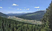
South Park (Park County, Colorado)
Grassland flat in Park County, Colorado, USSouth Park is a grassland flat within the basin formed by the Rocky Mountains' Mosquito and Rampart Mountain Ranges within central Colorado. This high valley ranges in elevation from approximately 9,000 to 10,000 ft. It encompasses approximately 1,000 square miles around the headwaters of the South Platte River in Park County approximately 60 mi (100 km) southwest of Denver. It is the largest and southernmost of three similarly named high elevation basins in the Front Range of Colorado, the others being North Park and Middle Park. The largest town in the basin is Fairplay, with a population of 724.
Read article
Top Questions
AI generatedMore questions
Nearby Places

Trout Creek Pass
Mountain pass in Colorado, U.S.

Area codes 970 and 748
NANP telephone area codes for the U.S. state of Colorado

Antero Junction, Colorado
Ghost town in Park County, Colorado, United States

South Park National Heritage Area
United States National Heritage Area in Colorado

West Buffalo Peak
Mountain in the state of Colorado

East Buffalo Peak
Mountain in the state of Colorado
Salt Works Ranch
United States historic place


